
About Social Bookmarking
|
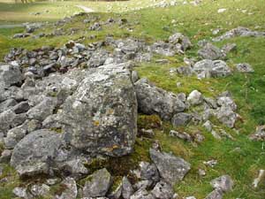
Great Close House The ruins of this house may be found situated on
Malham Moor on the Southeast side, and at the foot of Great Close
Scar at SD905666, just to the left of the road to Middle House after
leaving Street Gate. Known to locals as the old pub, the ruins were
more extensive in the mid 20th century but have been "quarried"
for stone. In 1710 it was home to the Tempest family, perhaps related
to James Tempest of Kirkby Malham and was a part of the original
Lister estates on Malham Moor.
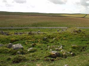
View of the ruins of Great Close House from the
south, The house was built alongside an ancient packhorse and monastic way running north and east to Arncliffe, west to Settle and south to Malham. It was also connected to a track extending north and west, via the northern bank of the Tarn, towards Fountains Fell, Langcliffe and beyond. Arthur Raistrick refers to the house in his book "Malham and Malham Moor" published in 1947, where on page 99 he states :
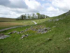
Thomas Hurtley in his book "The Natural Curiosities in the Environs of Malham in Craven" published in 1768 says that a Mr Birtwhistle of Skipton, a celebrated Craven grazier, persuaded the Scots that there was a market for their cattle in Craven, when he was travelling there in 1745. He rented the 700+ acres of Great Close as pasture and a place to hold the fair. Hurtley says: .....you might often see 5,000 head of Scotch cattle in the pasture at one time. As soon as these were a little freshened, notice was dispersed among the neighbouring markets and villages that a Fair would be held on a particular day ; and lots being separated by guess as nearly as could in such a manner be done to the -wants or wishes of any purchaser, so much was fixed immediately by the eye upon that lot or so much per head taking them as they accidentally were intermixed upon an average. As soon as these were disposed of,' continues Hurtley, ' a fresh drove succeeded and besides sheep and horses frequently in great numbers, Mr Birtwhistle has had 20,000 head of cattle on this field in one summer. Morkill says the sales of Scotch cattle on Great Close is believed to have carried on into the early 19th century, but was gradually replaced by sheep. However once the railways were established in the mid 19th century the shepherds and drovers no longer brought their animals to Malham and the fair became the much smaller Malham sheep sales, which continued through the 20th century. Today, to a casual observer, it is perhaps hard to appreciate that this expansive solitude would have been shattered by the noise and bustle, of a cattle fair. The shouts of commands in thick foreign accents, the constant arrival and departures of man and beasts and perhaps the sounds of merriment at the refreshment house. Examination of the scant remains reveal, to the laymans eye, the following features:
Looking at Henry O’Hagan's map of 1850 which shows part of Thomas Lord Ribblesdales Estate in Kirkby Malhamdale (which was part of the1850 prospectus for the sale of the estate (YAS), the house location, although not originally named, can been clearly identified together with the linking track to the Southwest. Also the drawing seems to show an extension out from the right hand front elevation, but this isn't confirmed by the first edition of the 6 inch OS map of a similar date. The survey of the Fountains Abbey estates made at the surrender of the monastery in 1539 doesn't mention a tenancy on Great Close, so it can reasonably be assumed that the remains are later than this date, probably when the land was in the possession of the Lamberts.

Shepherds Cottage, Waterhouses,
Malham Moor, similar
to the buildings envisaged at Great Close.
The Parish Registers for Kirkby Malham (1597-1690) were published by Yorkshire Parish Register Society and record some of the families living at Great Close House: Peter Verley of the great close & Margaret Fyshe of the same, was married xviiij of July in ano pdco, 1614 (p. 75) Peter Varley sepult 20 November 1626 John son of Jo. Hartley of Great Close was buried 10th day of January 1682 (p. 182)Alice daughtr. Of John Hartley of Great Close buried 22 day of December 1685 (p. 174) The Bishop's Transcripts in the Borthwick Institute provide:
NB. How this fits within my Tempest Family, if indeed they do, remains to be determined - Barrie Sharples Further site photographs taken June
2003.
Notes: Findings of the North Yorkshire and Cleveland Vernacular Buildings Study Group, summarised by Barry Harrison and Barbara Hutton. They found that based on surveys of 107 houses: That by national standards, Craven was at this period, relatively advanced, and evidenced by:
Photographs and information on this page have been
supplied by
whose family history research includes the Tempests of Kirkby Malhamdale.
|
||||||
|


![]()